I have given this question a lot of thought. I've been licensed since 1989, that's 25 years of very active operating. I'm #1 on the Honor Roll, over 1,030 IOTA's confirmed, 5BWAZ, 9 Band DXCC, etc... So, as you can tell, I love the hobby. Given all my ham radio acheivements and activities I can't recall being so enthused about any part of the hobby as I am about the Summits on the Air program. So why is that? I came up with a few thoughts.
I enjoy QRP because it fits my minimalist philosophy of life. What is it that I really need to exist? Operating QRP is like catching a 10 lb. bass on 3 lb test line, it's like sleeping under a lean-to rather than a tent, using an EFHW instead of a beam, it's like David versus Goliath. In short, its a challenge to begin with and thrill when you succeed.
I like managing the gear. I'm always looking for better ways to manage a summit activation from logging to power supplies to antennas to radios. I 'm always looking for the lightest, most efficient approach. I like that no two activations are exactly alike. Deciding where to set-up, which tree has the best antenna support characteristics, where is best protection from the elements. The shack at home changes very little over time. It's almost boring.
I like the planning, topographic maps, coordinates, routes. I like the exercise, the incentive to stay fit so that I can enjoy what nature has to offer regardless of the altitude. I love the views. It makes me feel alive.
I like the points, the sense of achievement, although it's not always the achievement, it's the chase. The pursuit of the goal is what is motivating. I enjoy the chase.
I enjoy the comradarie of like minded indivduals and the SOTA program is very strong in that regard, it's full of people who love the outdoors, who enjoy QRP and like the challenges of both.
I just had to write it down.
Friday, May 30, 2014
Wednesday, May 28, 2014
Music and Mountains
This past Monday was Memorial Day in the US. A day to remember those who paid the ultimate sacrifice in defense of Freedom and our Country. I am grateful for the dedication and patriotism of these Americans.
Memorial Day Weekend is therefore a Holiday weekend that finds many of us enjoying a three day weekend. The weekend was busy and memorable one for me. The weekend began with a 300 mile drive to play a show with my band, The No Refund Band, at a venue in Crystal Beach, TX. Crystal Beach is on the Bolivar Peninsula, east of Galveston Island on the Texas Coast. We had a great show there. (You can check out my band at norefundband.com )
The next morning (Sunday), my XYL Cris and I got in the Jeep and headed to the Ouachita Mountains in Oklahoma. This would be a 430 mile drive with the purpose of getting as many SOTA points as possible. The drive from Houston was very nice. North of Houston you take Hwy. 19 which goes through the piney woods of east Texas. Of course Texas is a big state and on this highway alone I went through Palestine, Athens, Canton and Paris. The road is nice and the speed limit is 70 - 75 mph and the traffic was light. As long drives go, this one wasn't bad.
The Ouachita Mountains cover southeastern Oklahoma and west central Arkansas. Along with the Ozark Mountains, the Ouachita Mountains form the U.S Interior Highlands, one of the major mountainous regions between the Rocky Mountains and the Appalachian Mountains. It is a beautiful area that is very green and lush with mountains and valleys that induce tranquility.
From a SOTA perspective I had done my research to find the most efficient route to accumulate the most points in relatively short amount of time. I had to be backon Tuesday for work, so I would have 24 hours get as many points as possible.
Sycamore Lookout W5O/OU-005 (8 pts)*
We arrived 20:15 UTC. The summit has easy access from the highway and I was QRV by 20:35. I set up next to the commercial antenna's with no RF issues. The bands were not in good shape and the WPX contest was in full swing. I made 10 QSO's in 25 minutes on 17 and 40 meters and decided to move on to the next one.
Peak 2210 W5O/OU-006 (8pts)*
This summit is just up the road a few miles and the highway is in the activation zone. I did ascend about 50 feet vertically to the summit. I set up just below the summit ridge. Unfortunately, the cell service was spotty and I wasn't able to spot myself. For some reason I wasn't picked up by the RBN network either. Consequently I called CQ for 10 minutes on 17m with no responses. I finally had cell service long enough to get a call off to Fred, KT5X, to ask him to spot me. It still took me 10 minutes after the spot to get my 4 QSO's. Conditions were not good.
Winding Stair Mountain W5O/OU-002 (10 pts)*
Winding Stair Mountain is a nice hike. The trail head is across the road from the Campground and the hike is about 3 miles roundtrip. We encountered a troop of Boy Scouts training for their upcoming 68 mile trek at the Philmont Scout Ranch in New Mexico. Conditions were only marginally better, I made 11 QSO's in 25 minutes.
After this summit we made out way to the Green Country Inn in Heavener, Oklahoma where we had a room. The hotel is a great place to stay if you find yourself in the area. The next morning began early to make sure we got to the summits we planned.
Lynn Mountain W5O/OU-001 (10 pts)*
Getting to this summit is best done with a 4WD vehicle. While a 2WD would make it most days, a 4WD is preferred. The road does enter the activation zone, but I took an ATV trail for the short walk to the summit. This summit is very green and overgrown so I operated from the trail. The weather was overcast and as I left the Jeep it started to rain. We were prepared with rain gear and umbrellas to provide a mini-shack on the summit. There was a light rain during the entire activation. Conditions were a little better and, since the WPX contest was over, 20m was available again. I was on the air at 1335 UTC, so I think I was a little early for propagation and some late rising operators. I made 12 QSO's on 20m and 40m.
Pigeon Benchmark W5O/OU-013 (10 pts)*
This summit is off the same road as Lynn Mountain. The hike to the activation zone is a 2 mile round trip. The trail to the summit is an overgrown ATV trail. The walking is easy with about a 220 foot elevation gain over the mile to the top. The grass on the trail is knee high and it was wet from the rain, so it was a very wet hike. Conditions were much better as I was QRV at 1510 and made 20 QSO's on 20 and 40 meters.
Rough Mountain W5O/OU-014 (8 pts) *
The road to this trail head requires a 4WD. The road crosses the Ouachita trail a about a mile in from Hwy. 259. This is nice 2.5 mile round trip hike with about 500 ft. elevation gain over the 1.25 miles to the summit. The trail is nice. I made 22 QSO's from here.
*Additional details on how to get to these summits can be found on the SotaWatch page for each summit
So there you have it, 54 SOTA points in 24 hours. We had a 500 mile drive home that we made in about 8 hours. So in total we traveled 1,200 plus miles to enjoy music and mountains to make memorable Memorial Day weekend.
A short highlight video can be found here:
https://www.youtube.com/watch?v=NZhGh-XATJ0
Wednesday, May 21, 2014
Call CQ
In todays digital, interconnected, instant access world we have become very dependent on gadgets, websites and notifications. In ham radio, if you chase DX at all, the cluster is probably your primary tool to see who is on from where. I know that I have become accustomed to checking the cluster and if there is nothing interesting I will go do something else with the idea that the bands are dead. There there are times when I check the low end of 20 meters to see what good DX might be available and more often than not, the band is quiet. In the old days, the lower end of 20m was a treasure trove of DX. I wonder to myself if ham radio is waning in popularity. However ,when a rare country appears, its chaos with unending pile-ups. I am forced to conclude that we are all watching the cluster.
The other night I actually called CQ on 20 meters. In short order I had a nice pile-up of Europeans, then someone spotted me and the pile-up increased significantly. Everyone must be watching the cluster, thats why the bands are quiet. I think we should all make it a practice to call CQ with some regularity. Tune the bands to see how much DX you can pick up without the cluster. How long will it take you to work DXCC without the cluster, or how many countries can you work in month by calling CQ. If we all do a little of this, the lower end of 20m would came alive again.
The other night I actually called CQ on 20 meters. In short order I had a nice pile-up of Europeans, then someone spotted me and the pile-up increased significantly. Everyone must be watching the cluster, thats why the bands are quiet. I think we should all make it a practice to call CQ with some regularity. Tune the bands to see how much DX you can pick up without the cluster. How long will it take you to work DXCC without the cluster, or how many countries can you work in month by calling CQ. If we all do a little of this, the lower end of 20m would came alive again.
Saturday, May 3, 2014
Texas SOTA Trip - The Law of Averages
The "Law of Averages" is a layman's term used to express a belief that outcomes of a random event will "even out" over time. While statistical experts may argue the validity of this thinking in the short term, what do they know anyway. So, you may ask, what does the law of averages have to do with SOTA?
As I have written here recently, the SOTA program recently added 40+ one point summits in South Texas. These summits are within a reasonable drive for me, so I was enthusiastic to activate them and after all, they are all one pointers, they should be easy enough. Just as a reminder for those who haven't caught the SOTA virus yet, point values range from 1 - 10. Oddly enough, 1 is the only odd number used in the valuation scale. Summits can be worth 1,2,4,6,8 or 10 points. Don't ask, I have no idea.
I've already activated Peak 2002, which was the first South Texas group summit activation. I ended up walking 8 miles for that point. Not to worry though, they can't all be that long. So in the spirit of adventure (and not point accumulation), I planned to activate two of these summits during the International SOTA day and the QRP to the field (QRPTTF) events. My two targets were Bullhead Mountain, W5T/ST-007, and Pikes Peak, W5T/ST-029. Yes there is a Pikes Peak in Texas. The one in Colorado is worth 10 points, the Texas version is worth, the aforementioned, one point.
I'd done my research and determined that there was a better than even chance these summits would be accessible. While on private land, these peaks are in sparsely populated areas that likely aren't posted. However you never know until you get there.
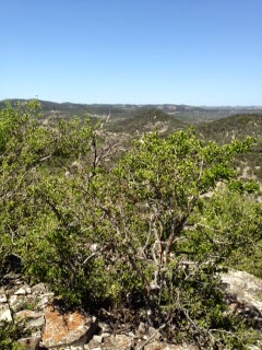
Bullhead Mountain, W5T/ST-007, is a limestone peak north of Vance (formerly Bullhead) and the intersection of Farm roads 335 and 2631 in far western Real County (at 29°49' N, 100°00' W). The summit, at an elevation of 2,042 feet above sea level, rises on the southern edge of the Edwards Plateau. Local vegetation includes open stands of live oak, Ashe juniper, and mesquite on the uplands and ridges and live oak and Ashe juniper woods on the hills and escarpments.
The best approach to this summit is from the Farm Road 335 side or the south side of the mountain. The fence is deteriorated and it is not posted. The approach on the Hwy 2631 side is posted. This one pointer is no bargain. You will climb 400 feet in about 1/4 mile. Translated, that is steep and the extra bonus is that there are no trails. The slopes are covered with all manner of hard to get through trees and underbrush combined with loose rock to make for an adventurous descent. This is Bushwhacking with a capital B. We did finally summit and had some nice views.
The bands were a little finicky. Only made QSO's on 20 meters. Nothing on 12m despite the RBN hearing me at PJ2T.
So after the descent of Bullhead Mountain, we made the short drive to Pikes Peak to discover what awaited us there. Pikes Peak, W5T/ST-029 is a mile north of Camp Wood in extreme southeast Edwards County (at 29°41' N, 100°02' W). It rises to a height of 1,904 feet, 470 feet above the nearby Nueces River. The summit was named for Zebulon Pike, whose exploring party passed near it on its return from the exploration of Colorado in 1807. The area's steep to gentle slopes are surfaced by variable soil that supports scrub brush and sparse grasses.
This summit was every bit as tough a Bullhead. There is a road that goes over the shoulder of the mountain which means you only have to climb 300 feet in about 1/3 of a mile. Again, that's steep and again no trails. I operated from the very top of the summit. A nice breeze cooled us down for the now 85F temperatures.
Propagation had warmed up a little by the time we summited, but not much. I doubled my QSO count on this summit, but still most of the business came from 20m. I was able to work five summit to summit contacts which is always rewarding. Portable QRP to portable QRP, from mountain to mountain. Pretty cool. The high bands, 12m and 10m were not really productive, only one QSO on 12m and none on 10m.
We had contemplated doing Wildcat Peak also. Another one pointer, not too far from Pikes Peak, however, we were tired. These ascents and descents were taxing because of the steepness and the full time bushwhacking through brush and the temperatures were warming up. My thermometer in my jeep read 90F when we got down. We had a nice Texas lunch in Camp Wood. A lunch buffet with Mexican food and Chicken Fried Steak. It doesn't get much better than that.:-)
So, what about this Law of Averages? Well, in the SOTA world there are some easy summits. Some you can even drive up to the summit or park near the top and take a nice trail a few yards to the summit. I have felt a little guilty about that in the past, getting so many points for so little effort, but no more. The Law of Averages does apply to SOTA. These one pointers were intense, difficult mountains to do. However, I suppose it all averages out. After doing these mountains, my guilt in doing an easy one has disappeared:-)
Photo credits to my XYL Cris, KC5HZQ
Excerpts above were taken from the Texas State Historical Association.
As I have written here recently, the SOTA program recently added 40+ one point summits in South Texas. These summits are within a reasonable drive for me, so I was enthusiastic to activate them and after all, they are all one pointers, they should be easy enough. Just as a reminder for those who haven't caught the SOTA virus yet, point values range from 1 - 10. Oddly enough, 1 is the only odd number used in the valuation scale. Summits can be worth 1,2,4,6,8 or 10 points. Don't ask, I have no idea.
I've already activated Peak 2002, which was the first South Texas group summit activation. I ended up walking 8 miles for that point. Not to worry though, they can't all be that long. So in the spirit of adventure (and not point accumulation), I planned to activate two of these summits during the International SOTA day and the QRP to the field (QRPTTF) events. My two targets were Bullhead Mountain, W5T/ST-007, and Pikes Peak, W5T/ST-029. Yes there is a Pikes Peak in Texas. The one in Colorado is worth 10 points, the Texas version is worth, the aforementioned, one point.
I'd done my research and determined that there was a better than even chance these summits would be accessible. While on private land, these peaks are in sparsely populated areas that likely aren't posted. However you never know until you get there.
Bullhead Mountain, W5T/ST-007, is a limestone peak north of Vance (formerly Bullhead) and the intersection of Farm roads 335 and 2631 in far western Real County (at 29°49' N, 100°00' W). The summit, at an elevation of 2,042 feet above sea level, rises on the southern edge of the Edwards Plateau. Local vegetation includes open stands of live oak, Ashe juniper, and mesquite on the uplands and ridges and live oak and Ashe juniper woods on the hills and escarpments.
 |
| The Trail up Bullhead, One of more open areas |
 |
| Operating from Bullhead Mountain |
 |
| View from Bullhead Mountain |
The bands were a little finicky. Only made QSO's on 20 meters. Nothing on 12m despite the RBN hearing me at PJ2T.
 |
| Cris and I. Our Jeep is the black speck on the road |
 |
| View from Pikes Peak |
This summit was every bit as tough a Bullhead. There is a road that goes over the shoulder of the mountain which means you only have to climb 300 feet in about 1/3 of a mile. Again, that's steep and again no trails. I operated from the very top of the summit. A nice breeze cooled us down for the now 85F temperatures.
 |
| Operating from the Summit of Pikes Peak, Texas |
We had contemplated doing Wildcat Peak also. Another one pointer, not too far from Pikes Peak, however, we were tired. These ascents and descents were taxing because of the steepness and the full time bushwhacking through brush and the temperatures were warming up. My thermometer in my jeep read 90F when we got down. We had a nice Texas lunch in Camp Wood. A lunch buffet with Mexican food and Chicken Fried Steak. It doesn't get much better than that.:-)
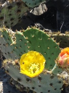 |
| Cactus Flowers |
 |
| Texas Mountain Fauna |
So, what about this Law of Averages? Well, in the SOTA world there are some easy summits. Some you can even drive up to the summit or park near the top and take a nice trail a few yards to the summit. I have felt a little guilty about that in the past, getting so many points for so little effort, but no more. The Law of Averages does apply to SOTA. These one pointers were intense, difficult mountains to do. However, I suppose it all averages out. After doing these mountains, my guilt in doing an easy one has disappeared:-)
Photo credits to my XYL Cris, KC5HZQ
Excerpts above were taken from the Texas State Historical Association.
Subscribe to:
Posts (Atom)