North America SOTA Activity Weekend is a casual event involving tiny battery-powered radios on mountain summits. It is not a contest but is intended to introduce "Summits on the Air" to newcomers with home stations who try to work summit operators during one or two days. There are no rules regarding power levels, modes or number of bands worked, but please be courteous when more than one station is trying to talk to a SOTA operator on a summit. The SOTA operators have just climbed mountains as high as 14,000 feet; they use low power; and they don't receive on split frequencies.
Check SOTAWATCH.org to spot who is on which mountain. Summits are numbered, and you can hover your cursor over the number to see the name and point value for each summit. Expect the website to show activity near 7.032, 7.185, 10.110, 14.342, 18.095, 18.155, 21.350, 24.905, 24.955, 28.420, 146.52, 446.00, and 61 Khz up from the bottom of 20, 15 and 10 meters CW. Don't be deceived by the QRP power levels, these guys have some nice antenna supports.
Participants are invited to collect points toward certificates and trophies offered by the eleven-year-old international SOTA group (SOTA.org.UK). As we learned in past years, this is a barrel of fun for both hill climbers and home operators. See you then.
The folks at NA-SOTA.org
Saturday, August 24, 2013
Thursday, August 22, 2013
Busy Days, Fun Days, Two Summits in New Mexico
It have been a very busy couple of weeks. For the two or three of you that follow my blog, you have probably noticed the recent silent period. Worry not, I haven't been slacking on radio adventure. As some of you may have noticed, I have been activating a few summits around New Mexico. Well my wife an I have looking for a vacation home in Santa Fe. We weren't in any hurry and wanted to find just the right spot. Well, we found it and spent last week buying it and furnishing it. It is in a non-ham friendly neighborhood, but that makes for more of a challenge. My plan is to do most of my radioing outside anyway. There are summits galore. While I was there tending to moving-in activities I did find time to activate a couple of summits. Below are some brief summaries.
Glorieta Mesa W5N/PW-032 August 16, 2013
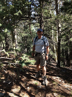
This was my first solo summit. I've done summits with other activators and my wife often does the hike with me, however this time I was on my own. Glorieta Mesa is an 8 point summit whose elevation is just over 8,000 ft. Finding the route required a little research but the SOTA website is very valuable in finding routes if previous activators have uploaded their activation notes. Such was the case here and I was able to get two sets of coordinates, the first directed me where to park and the second pinpointed the previous operating location of another activator. Given those two points the hike was fairly straight forward. Only about 300 feet elevation gain over 1.5 mile climb isn't too bad.
I used my GPS unit with it's TOPO map to navigate to the activation zone. There is no trail per se on this climb. I would classify it as a minor bushwhack. While there are no trails the forest is very walk-able with a few brushy areas that you have to walk through, but not bad.
There were some very nice views on the way to the top as evidenced by the picture to the left.
Once on the top I used my ATS-4 and my modified Buddi-Stick vertical. Conditions were decent and after couple of CQ's I had a nice SOTA Chaser pile-up. I managed to work 18 stations in a 20 minute span working stations Coast to Coast.
A Chaser pile-up is the ultimate QRP thrill in my opinion. You are operating a station that you carried up the hill on your back, using a portable antenna and other stations are actually chasing you. The signals were loud and I was getting some 569 and 579 reports.


Glorieta Mesa W5N/PW-032 August 16, 2013
This was my first solo summit. I've done summits with other activators and my wife often does the hike with me, however this time I was on my own. Glorieta Mesa is an 8 point summit whose elevation is just over 8,000 ft. Finding the route required a little research but the SOTA website is very valuable in finding routes if previous activators have uploaded their activation notes. Such was the case here and I was able to get two sets of coordinates, the first directed me where to park and the second pinpointed the previous operating location of another activator. Given those two points the hike was fairly straight forward. Only about 300 feet elevation gain over 1.5 mile climb isn't too bad.
I used my GPS unit with it's TOPO map to navigate to the activation zone. There is no trail per se on this climb. I would classify it as a minor bushwhack. While there are no trails the forest is very walk-able with a few brushy areas that you have to walk through, but not bad.
 |
| On The Way Up |
Once on the top I used my ATS-4 and my modified Buddi-Stick vertical. Conditions were decent and after couple of CQ's I had a nice SOTA Chaser pile-up. I managed to work 18 stations in a 20 minute span working stations Coast to Coast.
A Chaser pile-up is the ultimate QRP thrill in my opinion. You are operating a station that you carried up the hill on your back, using a portable antenna and other stations are actually chasing you. The signals were loud and I was getting some 569 and 579 reports.
View from the Top
Operating Position
I was behind schedule, so I called it quits after about 25 minutes on the air. It was a satisfying trip down the Mesa, mission accomplished. Exercise, portable QRP, Chaser pile-up and 8 Activator points.
Thompson Peak W5N/PW-013 August 17th, 2013
Thompson Peak is a 10 point peak with an elevation at 10,554 ft. To get to the trail head you have to travel a 4WD road for ~15 miles. Once at the trail head the hike is fairly straight forward. The trail is easy to follow. There are some ups and downs on the hike before you get to the summit so its's not just an straight up and straight down hike. The trail is a little over 1.5 miles to the summit with a net 700 ft. climb, but because of the up and down nature of the trail the gross elevation gain might be twice as much.

AD5A on the Trail
My old friend and ex-ham Jeff accompanied me on this hike. A nice hike in the forest with an old friend is lots of fun. We enjoyed the hike and before we new it we were on the summit.

Summit Cairn
I used my trail friendly 10m/20m/40m/ EFHW antenna. I used my 21 foot collapsible carbon fiber pole to put the end of the wire over the highest branch I could reach and then used the pole as a support for the other end of the antenna. In no time I had a loud pile-up. There was some QSB as K index was 4, but I made 21 QSO's in ~30 minutes, all on 20 meters. I called CQ on 40m, but no joy there.

Operating from Thompson Peak
After several unanswered CQs, it was time to go. After packing up the station we headed down the hill, another mission completed and 10 more activator points on the scoreboard.
The nice thing about these two activations was that after I got down, I was able to go to my new home in Santa Fe rather than a hotel room. That was a first as well. My home QTH is 380 miles from the closest 10 pointer, so travelling is a must if you are to activate summits.
So, look for a few more New Mexico summits from me.
Monday, August 12, 2013
Do QRP'ers Have an Identitiy Crisis?
So I was browsing the QRP Blogs today and I read about the most recent QRP contest. It occurred to me that maybe QRPer's have self esteem issues. Two of the activities that seem to attract a lot of QRP'ers are, "The Flight of the Bumblebees" and "The Skeeter Hunt". So, as I contemplated the deeper meaning, both the bumblebee and the skeeter are annonying creatures that bite you and yes, even carry disease. People actually spray chemicals on themselves to keep bees and skeeters away. Now I ask you as a fellow QRP'er; is this really who we are? Skeeters and bees, should these be the mascots of QRPdom?
We should rather associate ourselves with the sly, skilled animals of the forests that we are, those that through their guile and agility are able to strike quickly and capture their prey. Why can't we have, "The Flight of the Eagles" or "The King of the Jungle Hunt". These symbols, or mascots if you will, would invoke a much stronger sense of purpose and pride, we can hold our heads high and make cool T-Shirts, while demonstrating to the world that indeed QRP'ers are a force to be reckoned with. We could say, "come join us in our hunt for the Lions this weekend", instead of "hey, wanna go skeeter hunting?".
Anyway, just some thoughts, skeeters and bees or Eagles and Lions.
Saturday, August 10, 2013
My Backpack Progression
A lot is written in the SOTA Blogosphere about backpacks and which one is the ultimate one for treks into the wilderness to operate portable. What can be quickly be deduced from these articles is that the ultimate backpack is a matter of taste and philosophy. Will you want to account for every possibility or have a quick exit strategy should something go wrong? Your philosophy can be driven by the circumstance, e.g., if I live in the mountains I am quick to abandon a summit attempt as I can always do it tomorrow. However, if I am in the mountains on a vacation or otherwise limited schedule, I might be prepared to endure more in-climate weather to get a summit activation in. Each philosophy dictates a different approach.
As with any activity the more experience you get, the more refined your approach becomes and so it has been with me. My first activation was last March. I took my KX3 with an FT-817 as backup, an Alexloop, a Buddistick, several coax jumpers (BNC - PL-259, BNC - BNC and other combinations just in case), a pound of trail mix and several bottles of water. All this for a 3.5 mile round trip. I didn't even want to weigh it.


As with any activity the more experience you get, the more refined your approach becomes and so it has been with me. My first activation was last March. I took my KX3 with an FT-817 as backup, an Alexloop, a Buddistick, several coax jumpers (BNC - PL-259, BNC - BNC and other combinations just in case), a pound of trail mix and several bottles of water. All this for a 3.5 mile round trip. I didn't even want to weigh it.
Pack Evolution
I started with the black Kelty, then the red North Face
and finally I've progressed to the CamelBack Fourteener in the middle
I started with a big pack and I filled it up, which is a big mistake. So I realized maybe I should downsize a little. So I began to rationalize what I carried. I realized that the KX3, while a very nice radio, is a lot to carry in both weight and bulk. I am really more of a CW guy, so I was carrying around a lot of capability that I didn't need. I owned an ATS-4 which weighs a few ounces and is a CW only rig with 5 bands. Also, the Alexloop is an effective antenna, but it's bulky and takes a lot space in a pack. For relatively long hikes, it's too much. The problem with bulk is that it makes you get a bigger pack and human nature dictates that you fill it up, so you unconsciously take more stuff. For an antenna I went to a trail friendly EFHW 40/20/10 supported by a carbon fiber fishing pole that telescopes to 21 feet.
If I am on a drive-up/walk-up summit, I might carry some of the bulky stuff because it's easy. I recently used the Alexloop on Mt. Locke because I didn't have to carry if far, sot the situation can dictate a different configuration.
The other consideration is water. You should get a pack that allows you to insert a water bladder with a drinking tube accessible to you while you are hiking. This not only allows you to drink on the go, it is a better way to carry water and eliminates the need for bulky water bottles.
As you can see above I have continually downsized my pack. The CamelBack Fourteener is about 1/3 the capacity of the Kelty that I started with. Below is what I carry.
Typical Activation Load
My radio is in an iPad portfolio along with the power supply, paddle and ear phones. I carry two antennas, a modified Buddi-stick and a carbon fiber telescoping fishing pole with an EFHW antenna, VHF radio, coax, GPS, log, first aid kit and rain gear. The pack above weighs about 9 lb. The bladder in this pack holds 100 ounces of water (gallon ~ 128 ounces). I been on an activation in the heat that was 9.5 miles round-trip and I had water left over, so you don't have to fill it up every time. Without water and without any food/snacks the above weighs, including the pack, about 9 lbs. I do have a redundancy with the antennas, but that is to allow for different conditions and what I have time for on the summit. If I lived in the mountains, I would only take one antenna.
I have climbed Mt Sherman, 14,036 feet and Emory Peak, 9.5 mile round trip using this pack and I haven't lacked anything that I needed.
However the game continues, I am still looking for ways to cut back.
Sunday, August 4, 2013
Emory Peak Activation
Emory Peak (7,825 ft) is the highest point in Big Bend National Park in Texas. As previously posted I had activated Mount Locke in the Davis Mountain the day before. Mt. Locke was a relatively easy activation , but I would earn my points and more on Emory Peak.
For those not familiar with the Summits on the Air (SOTA) program there are bonus points added for activating a summit either during the winter in cold climates or during the summer in hot climates. West Texas is definitely a hot climate. Emory Peak is a 10 point summit (maximum), but activating in the summer months is worth 3 extra bonus points. On the drive from Mt. Locke to the Big Bend area temperatures hovered between 99 F to 101 F. The temperatures would moderate a little at the Chisos basin where we were staying, although not a lot. The Chisos Mountain Lodge is around 5500 feet in elevation, but the high temperatures during this time of year are in the low 90's.
The Chisos Mountain range within Big Bend National Park is a beautiful place. Emory peak may be the only peak that is climbable, but even then, you must climb the last 35 feet using some, not so easy, rock climbing techniques. I would not recommend it if you aren't experienced.
The trail to the summit of Emory Peak is a very nice trail. It is well marked and maintained. The only issue is that the round trip is 9.4 miles and there is 2,500 feet of elevation gain. Given that distance the elevation gain is not particularly difficult, if you are accustomed to mountain hikes, but it is a long way.
Emory Peak Trail
The Peak is in the background
We started relatively early, 7:30 am. I wanted to start sooner, but my XYL was nervous about the warning about hiking too early. The Big Bend National Park and the Chiso's Mountains in particular have Mountain Lion and Black Bear populations. Both are sighted quite often, but Mountain Lions in particular are active in the early morning. We had to check out of our hotel room at the Chisos Mountain Lodge by 1:00, so we needed to depart the summit by 10:30 by my calculation to get back in time. I figured 2.5 hours up, 30 minutes to operate and then 2 hours back down. If my calculations were correct, 7:30 was the latest we should start. My wife and I are in relatively good shape, so I felt 2 miles an hour was a doable pace considering we were gaining 2,500 feet.
 |
| Cris, my XYL, just below the summit |
 |
| AD5A just below the Summit VHF Antenna above are on the Summit |
The hike up wasn't too bad. Most of it is in the shade as the sun comes up over the mountains. It is a nice hike through a mostly forested trail. The last mile up was exposed to the sun, but there were still patches of shaded forest and the temps were bearable. We reached the summit around 10:00 am, right on schedule.
From my research I know that there weren't any tall trees on the summit, so getting an End Fed Half Wave antenna high enough would be an issue. I also know that time would be short with a hike this long, in the heat, so I needed to be able to deploy quickly. I decided on the Buddi-stick vertical. I only planned to operate on 20m, given the short time, so the vertical made sense.

 |
| Emory Peak Shack You can see the Buddi-stick if you look closely |
So I quickly deployed the station knowing that I would only have a short time to operate. I propped he vertical against a tree limb and then extended the counter poise over another limb. I took out my SOTA notebook station, seen above, plugged in the LIPO battery to ATS-4 QRP radio, grabbed my Porta-Paddle and I was ready to go. I called my first CQ at 10:13 am CDT. My good friends from Santa Fe, NM, Doc, K7SO and John, K1JD were monitoring my advertised frequency of 14.061. Doc answered my QRL? :-) John quickly followed. What then happened was SOTA bliss. The vertical was working well and in the next 15 minutes I made 21 QSO's. I wished that I had more time, but we needed to get off the mountain, both to beat the heat and to avoid an additional day's charge on our hotel room. So I took the station down as quickly as it went up, packed it all up and Cris and I headed down the mountain. We didn't get away until 10:45, a little behind schedule.
The trip down was uneventful, just long and the last mile or so, the heat was getting just a little on the uncomfortable side. However we were fully prepared, we carry 100 oz Camel Back water bladders in our pack, so we stayed hydrated. We made it back to our room at 12:55 pm. The good people at the Chisos Mountain Lodge let us shower and clean up before check out without an additional charge. I personally think it was self serving on their part as they didn't want us eating in their restaurant smelling like we just came off the trail:-)
This was a challenging hike, but completing it left us feeling good that we can still do it. The radio portion of the adventure came off without a hitch, so it was a good day in the Chisos.
Thursday, August 1, 2013
SOTA Activation, Locke Mountain, Davis Mountains, TX
This was fun activation today. Locke Mountain is the home of the McDonald Observatory and you can drive most of the way to the top. There is a short climb to the summit from the parking lot. Locke Mountain is in the Davis Mountains which this time of the year is like an oasis in West Texas. Everything is green and the mountains are beautiful. The only problem with this area is that so many of the peaks are on private property. I need to do a little more research to find ways to get on them. I tried to get permission to do Guide Peak, another 10 pointer close to Locke Mountain, but the owner said no, this time.
Today,because of a potentially crowded summit, it wasn't, I used an Alex Loop for the first time. Very pleased with the results, ~30 QSO's on 4 bands with my ATS-4. I actually did two stints on the summit. After lunch in Fort Davis I went back up to try to work a few more guys while my wife shopped in town. Fort Davis is a very nice town.
Tomorrow I will try Emory Peak in Big Bend National Park, W5T/CI-009. This is a 9 mile round trip. I will be on the trail early, but if it gets too hot, I will call it a day. Check out www.sotawatch.org for spots. I will try to summit between 1400-1500z on 2 Aug.
Tomorrow I will try Emory Peak in Big Bend National Park, W5T/CI-009. This is a 9 mile round trip. I will be on the trail early, but if it gets too hot, I will call it a day. Check out www.sotawatch.org for spots. I will try to summit between 1400-1500z on 2 Aug.
Subscribe to:
Posts (Atom)